Local Government
East Fremantle
Region
Metropolitan
34A Alexandra Rd East Fremantle
Previously 34-36 Alexandra Rd
East Fremantle
Metropolitan
| Type | Status | Date | Documents |
|---|---|---|---|
| Heritage List | Adopted | 17 Nov 2015 |
| Type | Status | Date | Documents |
|---|---|---|---|
| (no listings) |
| Type | Status | Date | Grading/Management | |
|---|---|---|---|---|
| Category | ||||
| Municipal Inventory | Adopted | 15 Aug 2006 | Category B | |
Individual Building or Group
| Epoch | General | Specific |
|---|---|---|
| Present Use | RESIDENTIAL | Terrace housing |
| Original Use | RESIDENTIAL | Terrace housing |
This information is provided voluntarily as a public service. The information provided is made available in good faith and is derived from sources believed to be reliable and accurate. However, the information is provided solely on the basis that readers will be responsible for making their own assessment of the matters discussed herein and are advised to verify all relevant representations, statements and information.
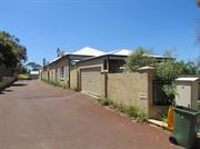
Aesthetic & Representative STATEMENT OF SIGNIFICANCE No 34A Alexandra Road is a single storey house constructed in limestone and brick with a corrugated iron roof. It has historic and aesthetic value for its contribution to Richmond's high concentration of predominantly Federation and Inter-War period houses and associated buildings. The place contributes to the local community’s sense of place. The place has some aesthetic value as a Federation Bungalow albeit some modifications. The place retains a moderate to low degree of authenticity and a high degree of integrity. The additions and residence to the rear have no significance. The carport and additions to the front additions are intrusive. AESTHETIC SIGNIFICANCE No 34A Alexandra Road has some aesthetic value as a Federation Bungalow. It retains some of the characteristic features of a dwelling of the type and period. HISTORIC SIGNIFICANCE No 34A Alexandra Road has considerable historic value. It was part of the suburban residential development associated with the expansion of East Fremantle and the subdivision of Stephen Henry Parker and James Morrison’s and then Walter Easton’s Estate from 1901. SCIENTIFIC SIGNIFICANCE N/A SOCIAL SIGNIFICANCE No 34A Alexandra Road has some social value. It is associated with a significant area of middle class Federation and Inter-War period development which contributes to the community's sense of place.
No 34A Alexandra Road is a single storey house constructed in limestone and rendered brick with a corrugated iron roof. The core house appears to be in the mid section. The original house has an ‘M’ format roofed section with a part width return verandah. The front facade features a pair of double hung sash windows. There are additions to the front of the house including a carport. The front addition is constructed of concrete blocks. Openings can be seen on the north elevation. The openings include modified openings at the western end and some original window openings to the east. The roofscape features rendered chimneys. The place retains some of its form and details. There are additions to the rear. The lot has been subdivided and a house built to the rear. An access lane has been constructed to the north of the place. The place is consistent with the building pattern in the Precinct. The place plays an important role in the pattern of development of a middle class suburb. CONSTRUCTION MATERIALS Walls – Limestone and brick Roof – Corrugated iron sheeting PHYSICAL SETTING The residence is situated on a sloping site with a limestone wall and steel palisade fence on the lot boundary.
Historic Theme: Demographic Settlement In September 1883 Stephen Henry Parker and James Morrison of Perth commenced subdivision of 65 acres of land to the north of Canning Road. The subdivision occurred at Swan Locations 63, 176, 219 and the south western portion of Swan Location 306. The subdivision included Preston Point Road, Alcester Gardens, Wolsely Gardens, Victoria Road, Alexandra Road, Parry Avenue, and Salvado Avenue. The Richmond Precinct was owned by Walter Easton and was named after the town of Richmond where Easton lived in England. In 1901 Easton’s sons subdivided Windsor Estate. New streets to the subdivision of the Windsor Estate were named after various members of the Easton family; Walter, Gill, Stratford and Morgan (later Osborne Road). Initially lot sizes were generous but sold at a slow rate. The initial development of the Richmond Precinct occurred at Canning Highway and Preston Point Road. Substantial residences were developed on these streets giving precedence to the future development of Richmond. The distinct architecture of Canning Highway and Preston Point Road distinguish Richmond from the surrounding area. By 1913 there were approximately 40 residences in the area between Preston Point Road and Alexandra Road. Osborne Road, Windsor Road and Gill Street had several buildings apiece by 1913. By 1931 approximately half the lots were developed. In 1921 Richmond Primary School was developed between Windsor and Osborne Road and several Inter-War residences were developed in the immediate area. In the 1930s the Workers’ Homes’ Board developed a number of weatherboard, asbestos, brick and tiled residences. Inter-War style front porches were preferred over Federation style full width verandahs. Redevelopments have occurred throughout the Richmond Precinct. Large lot sizes have allowed Richmond to be subject to the redevelopment of group and multiple housing. However, significant clusters of heritage dwellings remain throughout. HISTORIC THEME Demographic Settlements - Residential Subdivision
Integrity: High
Fair
| Reserve | Lot/Location | Plan/Diagram | Vol/Folio |
|---|---|---|---|
| Lot 3 |
This information is provided voluntarily as a public service. The information provided is made available in good faith and is derived from sources believed to be reliable and accurate. However, the information is provided solely on the basis that readers will be responsible for making their own assessment of the matters discussed herein and are advised to verify all relevant representations, statements and information.
38 Alexandra Rd East Fremantle
East Fremantle
Metropolitan
| Type | Status | Date | Documents |
|---|---|---|---|
| Heritage List | Adopted | 17 Nov 2015 |
| Type | Status | Date | Documents |
|---|---|---|---|
| (no listings) |
| Type | Status | Date | Grading/Management | |
|---|---|---|---|---|
| Category | ||||
| Municipal Inventory | Adopted | 15 Aug 2006 | Category B | |
Individual Building or Group
| Epoch | General | Specific |
|---|---|---|
| Original Use | RESIDENTIAL | Single storey residence |
| Present Use | RESIDENTIAL | Single storey residence |
| Style |
|---|
| Federation Bungalow |
This information is provided voluntarily as a public service. The information provided is made available in good faith and is derived from sources believed to be reliable and accurate. However, the information is provided solely on the basis that readers will be responsible for making their own assessment of the matters discussed herein and are advised to verify all relevant representations, statements and information.
Aesthetic & Representative
Historic Theme Demographic Settlement
Integrity: Very High
Good
This information is provided voluntarily as a public service. The information provided is made available in good faith and is derived from sources believed to be reliable and accurate. However, the information is provided solely on the basis that readers will be responsible for making their own assessment of the matters discussed herein and are advised to verify all relevant representations, statements and information.
49 Alexandra Rd East Fremantle
East Fremantle
Metropolitan
| Type | Status | Date | Documents |
|---|---|---|---|
| Heritage List | Adopted | 17 Nov 2015 |
| Type | Status | Date | Documents |
|---|---|---|---|
| (no listings) |
| Type | Status | Date | Grading/Management | |
|---|---|---|---|---|
| Category | ||||
| Municipal Inventory | Adopted | 15 Aug 2006 | Category B | |
Individual Building or Group
| Epoch | General | Specific |
|---|---|---|
| Present Use | RESIDENTIAL | Single storey residence |
| Original Use | RESIDENTIAL | Single storey residence |
| Style |
|---|
| Inter-War California Bungalow |
This information is provided voluntarily as a public service. The information provided is made available in good faith and is derived from sources believed to be reliable and accurate. However, the information is provided solely on the basis that readers will be responsible for making their own assessment of the matters discussed herein and are advised to verify all relevant representations, statements and information.

Aesthetic & Representative STATEMENT OF SIGNIFICANCE No 49 Alexandra Road is a single storey house constructed in rendered brick with a tiled roof. It has historic and aesthetic value for its contribution to Richmond's high concentration of predominantly Federation and Inter-War period houses and associated buildings. The place contributes to the local community’s sense of place. The place has considerable aesthetic value as an Inter-War Porch style house. The place retains a moderate to high degree of authenticity and a high degree of integrity. The carport, additions and house to the rear have no significance. AESTHETIC SIGNIFICANCE No 49 Alexandra Road has considerable aesthetic value as an Inter-War Porch style house. It retains most of the characteristic features of a dwelling of the type and period. HISTORIC SIGNIFICANCE No Alexandra Road has some historic value. It was part of the suburban residential development associated with the expansion of East Fremantle and the subdivision of Stephen Henry Parker and James Morrison’s and then Walter Easton’s Estate from 1901. SCIENTIFIC SIGNIFICANCE N/A SOCIAL SIGNIFICANCE No 49 Alexandra Road has some social value. It is associated with a significant area of middle class Federation and Inter-War period development which contributes to the community's sense of place.
No 49 Alexandra Road is a single storey house constructed in rendered brick with a hipped and gable tiled roof. It is a fine expression of the Inter-War Porch style. The place is built on a corner lot that addresses Alexandra Street and Parry Avenue. It is asymmetrically composed with a thrust gable bay and a part width low pitch roofed verandah. The verandah is supported on rendered masonry piers. A rendered masonry balustrade spans between the piers. The gable bay features a set of double hung sash windows under a sunhood. There is a central door flanked by a set of three double hung sashes. The roofscape features tall rendered chimneys and finials. The form of the battered piers and the wide shallow pitched roof are in the Inter-War California Bungalow style. The place retains most of its form and details. There are additions to the rear. A carport has been built to the north. The lot has been subdivided and a residence built to the rear. The rear residence addresses Parry Avenue. The place is consistent with the building pattern in the Precinct. The place plays an important role in the pattern of development of a middle class suburb. CONSTRUCTION MATERIALS Walls – Rendered brick Roof – Tiles PHYSICAL SETTING The residence is situated on a sloping site with a rendered retaining wall and a timber picket fence on the lot boundary.
Historic Theme: Demographic Settlement In September 1883 Stephen Henry Parker and James Morrison of Perth commenced subdivision of 65 acres of land to the north of Canning Road. The subdivision occurred at Swan Locations 63, 176, 219 and the south western portion of Swan Location 306. The subdivision included Preston Point Road, Alcester Gardens, Wolsely Gardens, Victoria Road, Alexandra Road, Parry Avenue, and Salvado Avenue. The Richmond Precinct was owned by Walter Easton and was named after the town of Richmond where Easton lived in England. In 1901 Easton’s sons subdivided Windsor Estate. New streets to the subdivision of the Windsor Estate were named after various members of the Easton family; Walter, Gill, Stratford and Morgan (later Osborne Road). Initially lot sizes were generous but sold at a slow rate. The initial development of the Richmond Precinct occurred at Canning Highway and Preston Point Road. Substantial residences were developed on these streets giving precedence to the future development of Richmond. The distinct architecture of Canning Highway and Preston Point Road distinguish Richmond from the surrounding area. By 1913 there were approximately 40 residences in the area between Preston Point Road and Alexandra Road. Osborne Road, Windsor Road and Gill Street had several buildings apiece by 1913. By 1931 approximately half the lots were developed. In 1921 Richmond Primary School was developed between Windsor and Osborne Road and several Inter-War residences were developed in the immediate area. In the 1930s the Workers’ Homes’ Board developed a number of weatherboard, asbestos, brick and tiled residences. Inter-War style front porches were preferred over Federation style full width verandahs. Redevelopments have occurred throughout the Richmond Precinct. Large lot sizes have allowed Richmond to be subject to the redevelopment of group and multiple housing. However, significant clusters of heritage dwellings remain throughout. HISTORIC THEME Demographic Settlements - Residential Subdivision
Integrity: High
Excellent
This information is provided voluntarily as a public service. The information provided is made available in good faith and is derived from sources believed to be reliable and accurate. However, the information is provided solely on the basis that readers will be responsible for making their own assessment of the matters discussed herein and are advised to verify all relevant representations, statements and information.
61 Alexandra Rd East Fremantle
East Fremantle
Metropolitan
| Type | Status | Date | Documents |
|---|---|---|---|
| Heritage List | Adopted | 17 Nov 2015 |
| Type | Status | Date | Documents |
|---|---|---|---|
| (no listings) |
| Type | Status | Date | Grading/Management | |
|---|---|---|---|---|
| Category | ||||
| Municipal Inventory | Adopted | 15 Aug 2006 | Category B | |
Individual Building or Group
| Epoch | General | Specific |
|---|---|---|
| Present Use | RESIDENTIAL | Single storey residence |
| Original Use | RESIDENTIAL | Single storey residence |
| Style |
|---|
| Old Colonial Georgian |
| Federation Bungalow |
This information is provided voluntarily as a public service. The information provided is made available in good faith and is derived from sources believed to be reliable and accurate. However, the information is provided solely on the basis that readers will be responsible for making their own assessment of the matters discussed herein and are advised to verify all relevant representations, statements and information.

Historic Theme: Demographic Settlement STATEMENT OF SIGNIFICANCE No 61 Alexandra Road is a single storey house constructed in rendered brick with a corrugated iron roof. It has historic and aesthetic value for its contribution to Richmond's high concentration of predominantly Federation and Inter-War period houses and associated buildings. The place contributes to the local community’s sense of place. The place has considerable aesthetic value as a Federation Bungalow. The place retains a moderate degree of authenticity and a high degree of integrity. The additions to the rear have no significance. AESTHETIC SIGNIFICANCE No 61 Alexandra Road has considerable aesthetic value as a Federation Bungalow. It retains most of the characteristic features of a dwelling of the type and period. HISTORIC SIGNIFICANCE No 61 Alexandra Road has some historic value. It was part of the suburban residential development associated with the expansion of East Fremantle and the subdivision of Stephen Henry Parker and James Morrison’s and then Walter Easton’s Estate from 1901. SCIENTIFIC SIGNIFICANCE N/A SOCIAL SIGNIFICANCE No 61 Alexandra Road has some social value. It is associated with a significant area of middle class Federation and Inter-War period development which contributes to the community's sense of place.
PHYSICAL DESCRIPTION No 61 Alexandra Road is a single storey house constructed in rendered brick with an ‘M’ format corrugated iron roof. It is a simple expression of the Federation Bungalow style. The house is constructed on a narrow lot. It is symmetrically composed with a full bull nosed roof verandah supported on timber posts. There is a central door flanked by double hung sash windows. The roofscape features a rendered chimney. The place retains most of its form and details. There are additions to the rear. The place is consistent with the building pattern in the Precinct. The place plays an important role in the pattern of development of a middle class suburb. CONSTRUCTION MATERIALS Walls – Rendered brick Roof – Corrugated iron sheeting PHYSICAL SETTING The residence is situated on a sloping site with a low masonry wall and a timber picket fence on the lot boundary. A hedge sits behind the fence.
Historic Theme: Demographic Settlement HISTORICAL NOTES In September 1883 Stephen Henry Parker and James Morrison of Perth commenced subdivision of 65 acres of land to the north of Canning Road. The subdivision occurred at Swan Locations 63, 176, 219 and the south western portion of Swan Location 306. The subdivision included Preston Point Road, Alcester Gardens, Wolsely Gardens, Victoria Road, Alexandra Road, Parry Avenue, and Salvado Avenue. The Richmond Precinct was owned by Walter Easton and was named after the town of Richmond where Easton lived in England. In 1901 Easton’s sons subdivided Windsor Estate. New streets to the subdivision of the Windsor Estate were named after various members of the Easton family; Walter, Gill, Stratford and Morgan (later Osborne Road). Initially lot sizes were generous but sold at a slow rate. The initial development of the Richmond Precinct occurred at Canning Highway and Preston Point Road. Substantial residences were developed on these streets giving precedence to the future development of Richmond. The distinct architecture of Canning Highway and Preston Point Road distinguish Richmond from the surrounding area. By 1913 there were approximately 40 residences in the area between Preston Point Road and Alexandra Road. Osborne Road, Windsor Road and Gill Street had several buildings apiece by 1913. By 1931 approximately half the lots were developed. In 1921 Richmond Primary School was developed between Windsor and Osborne Road and several Inter-War residences were developed in the immediate area. In the 1930s the Workers’ Homes’ Board developed a number of weatherboard, asbestos, brick and tiled residences. Inter-War style front porches were preferred over Federation style full width verandahs. Redevelopments have occurred throughout the Richmond Precinct. Large lot sizes have allowed Richmond to be subject to the redevelopment of group and multiple housing. However, significant clusters of heritage dwellings remain throughout. HISTORIC THEME Demographic Settlements - Residential Subdivision
Integrity: Very High
Fair
This information is provided voluntarily as a public service. The information provided is made available in good faith and is derived from sources believed to be reliable and accurate. However, the information is provided solely on the basis that readers will be responsible for making their own assessment of the matters discussed herein and are advised to verify all relevant representations, statements and information.
63 Alexandra Rd East Fremantle
East Fremantle
Metropolitan
| Type | Status | Date | Documents |
|---|---|---|---|
| Heritage List | Adopted | 17 Nov 2015 |
| Type | Status | Date | Documents |
|---|---|---|---|
| (no listings) |
| Type | Status | Date | Grading/Management | |
|---|---|---|---|---|
| Category | ||||
| Municipal Inventory | Adopted | 15 Aug 2006 | Category B | |
Individual Building or Group
| Epoch | General | Specific |
|---|---|---|
| Original Use | RESIDENTIAL | Terrace housing |
| Present Use | RESIDENTIAL | Terrace housing |
| Style |
|---|
| Federation Bungalow |
| Old Colonial Georgian |
This information is provided voluntarily as a public service. The information provided is made available in good faith and is derived from sources believed to be reliable and accurate. However, the information is provided solely on the basis that readers will be responsible for making their own assessment of the matters discussed herein and are advised to verify all relevant representations, statements and information.
Aesthetic & Representative
Historic Theme: Demographic Settlement
Integrity: High
Fair
This information is provided voluntarily as a public service. The information provided is made available in good faith and is derived from sources believed to be reliable and accurate. However, the information is provided solely on the basis that readers will be responsible for making their own assessment of the matters discussed herein and are advised to verify all relevant representations, statements and information.
72 Alexandra Rd East Fremantle
Bateman's
East Fremantle
Metropolitan
| Type | Status | Date | Documents |
|---|---|---|---|
| Heritage List | Adopted | 17 Nov 2015 |
| Type | Status | Date | Documents |
|---|---|---|---|
| (no listings) |
| Type | Status | Date | Grading/Management | |
|---|---|---|---|---|
| Category | ||||
| Municipal Inventory | Adopted | 18 Nov 1997 | Category A | |
Individual Building or Group
| Epoch | General | Specific |
|---|---|---|
| Present Use | RESIDENTIAL | Single storey residence |
| Original Use | RESIDENTIAL | Single storey residence |
| Style |
|---|
| Federation Bungalow |
| Inter-War California Bungalow |
This information is provided voluntarily as a public service. The information provided is made available in good faith and is derived from sources believed to be reliable and accurate. However, the information is provided solely on the basis that readers will be responsible for making their own assessment of the matters discussed herein and are advised to verify all relevant representations, statements and information.

Aesthetic & Representative STATEMENT OF SIGNIFICANCE No 72 Alexandra Road is a single storey house constructed in tuck pointed brick and rendered brick with a tiled roof. It has historic and aesthetic value for its contribution to Richmond's high concentration of predominantly Federation and Inter-War period houses and associated buildings. The place contributes to the local community’s sense of place. The place has exceptional aesthetic value as a Federation Bungalow style house with sympathetic additions. The place retains a moderate to high degree of authenticity and a high degree of integrity. The additions have no significance. AESTHETIC SIGNIFICANCE No 72 Alexandra Road has exceptional aesthetic value as a Federation Bungalow style house. It retains most of the characteristic features of a dwelling of the type and period. HISTORIC SIGNIFICANCE No 72 Alexandra Road has considerable historic value. It was part of the suburban residential development associated with the expansion of East Fremantle and the subdivision of Stephen Henry Parker and James Morrison’s and then Walter Easton’s Estate from 1901. SCIENTIFIC SIGNIFICANCE N/A SOCIAL SIGNIFICANCE No 72 Alexandra Road has considerable social value. It is associated with a significant area of middle class Federation and Inter-War period development which contributes to the community's sense of place.
No 72 Alexandra Road is a single storey house constructed in tuck pointed brick and rendered brick with a hipped tiled roof. It is a very fine expression of the Federation Bungalow style. It is symmetrically composed with a full width return verandah. The verandah is supported by turned timber posts with post brackets. A vertical timber balustrade spans between the posts. The north section of the verandah has been enclosed. The roofscape features tall rendered chimneys and finials. Walls are tuck-pointed brick with rendered string courses. The house is elevated above the garden. The entry door is located on the south elevation under the return verandah. The entry door and hopper light are flanked by sidelights and double hung sash windows. The place retains most of its form and details. There are additions to the rear. The place is consistent with the building pattern in the Precinct. The place plays an important role in the pattern of development of a middle class suburb. CONSTRUCTION MATERIALS Walls – Tuck pointed brick and rendered brick Roof – Tile PHYSICAL SETTING The residence is situated on a flat site with lawns and a richly planted garden tumbling over the front lot boundary.
Historic Theme: Demographic Settlement In September 1883 Stephen Henry Parker and James Morrison of Perth commenced subdivision of 65 acres of land to the north of Canning Road. The subdivision occurred at Swan Locations 63, 176, 219 and the south western portion of Swan Location 306. The subdivision included Preston Point Road, Alcester Gardens, Wolsely Gardens, Victoria Road, Alexandra Road, Parry Avenue, and Salvado Avenue. The Richmond Precinct was owned by Walter Easton and was named after the town of Richmond where Easton lived in England. In 1901 Easton’s sons subdivided Windsor Estate. New streets to the subdivision of the Windsor Estate were named after various members of the Easton family; Walter, Gill, Stratford and Morgan (later Osborne Road). Initially lot sizes were generous but sold at a slow rate. The initial development of the Richmond Precinct occurred at Canning Highway and Preston Point Road. Substantial residences were developed on these streets giving precedence to the future development of Richmond. The distinct architecture of Canning Highway and Preston Point Road distinguish Richmond from the surrounding area. By 1913 there were approximately 40 residences in the area between Preston Point Road and Alexandra Road. Osborne Road, Windsor Road and Gill Street had several buildings apiece by 1913. By 1931 approximately half the lots were developed. In 1921 Richmond Primary School was developed between Windsor and Osborne Road and several Inter-War residences were developed in the immediate area. In the 1930s the Workers’ Homes’ Board developed a number of weatherboard, asbestos, brick and tiled residences. Inter-War style front porches were preferred over Federation style full width verandahs. Redevelopments have occurred throughout the Richmond Precinct. Large lot sizes have allowed Richmond to be subject to the redevelopment of group and multiple housing. However, significant clusters of heritage dwellings remain throughout. HISTORIC THEME Demographic Settlements - Residential Subdivision
Integrity: Very High
Excellent
This information is provided voluntarily as a public service. The information provided is made available in good faith and is derived from sources believed to be reliable and accurate. However, the information is provided solely on the basis that readers will be responsible for making their own assessment of the matters discussed herein and are advised to verify all relevant representations, statements and information.
77 Alexandra Rd East Fremantle
East Fremantle
Metropolitan
Constructed from 1918
| Type | Status | Date | Documents |
|---|---|---|---|
| Heritage List | Adopted | 17 Nov 2015 |
| Type | Status | Date | Documents |
|---|---|---|---|
| RHP - Does not warrant assessment | Current | 31 Aug 2001 |
| Type | Status | Date | Grading/Management | |
|---|---|---|---|---|
| Category | ||||
| Municipal Inventory | Adopted | 15 Aug 2006 | Category B | |
In 2001 the place was noted to be in poor to average condition.
| Library Id | Title | Medium | Year Of Publication |
|---|---|---|---|
| 10253 | 77 Alexandra Road, East Fremantle. Photographic record. | Heritage Study {Other} | 0 |
Individual Building or Group
| Epoch | General | Specific |
|---|---|---|
| Present Use | RESIDENTIAL | Single storey residence |
| Original Use | RESIDENTIAL | Single storey residence |
| Style |
|---|
| Federation Queen Anne |
| Type | General | Specific |
|---|---|---|
| Other | CONCRETE | Concrete Slab |
| Roof | METAL | Corrugated Iron |
| Other | STONE | Limestone |
| Wall | ASBESTOS | Fibrous Cement, corrugated |
| General | Specific |
|---|---|
| DEMOGRAPHIC SETTLEMENT & MOBILITY | Settlements |
This information is provided voluntarily as a public service. The information provided is made available in good faith and is derived from sources believed to be reliable and accurate. However, the information is provided solely on the basis that readers will be responsible for making their own assessment of the matters discussed herein and are advised to verify all relevant representations, statements and information.

Aesthetic & Representative STATEMENT OF SIGNIFICANCE No 77 Alexandra Road is a single storey house constructed in rendered brick with a corrugated iron roof. The place is designed in the Federation Queen Anne style. It has cultural heritage significance at a local level for the following reasons: • No 77 Alexandra Road was the second residence built in the sub-division of Richmond Heights Estate. • The place is a representative example of a house designed in the Federation Queen Anne style in the decade 1910-1920, and as such contributes to the diversity of the residential styles and periods in the East Fremantle area. • No 77 Alexandra Road is representative of the development of the suburb of Richmond in the Town of East Fremantle, as one of only four residences built in the period 1917-30 on the 14 lots that comprised Richmond Heights Estate. • No 77 Alexandra Road is part of the streetscape of Alexandra Road, where most of the houses between Canning Highway and Wolsely Road date from the Federation period. It contributes to the assemblage of residential properties in the immediate street block and is part of the corner context that is created by the combination of No 77 and No 79. No 77 Alexandra Road is a place of significance at a local level and plays a contributory role in the cultural heritage of the Town of East Fremantle. The additions have no significance. AESTHETIC SIGNIFICANCE No 77 Alexandra Road has considerable aesthetic value as a typical Federation Bungalow. It retains some of the characteristic features of a dwelling of the type and period. HISTORIC SIGNIFICANCE No 77 Alexandra Road has some historic value as a representative example of a residence built in the immediate post World War One period. SCIENTIFIC SIGNIFICANCE N/A SOCIAL SIGNIFICANCE No 77 Alexandra Road has some social value. It is associated with a significant area of Federation cottages which contributes to the community's sense of place.
No 77 Alexandra Road is a single storey house constructed in rendered masonry with a hipped and gable corrugated iron roof. It is a simple expression of the Federation Bungalow style. The front elevation is asymmetrically planned with a thrust gable bay and a full width return hip roofed verandah. The verandah is supported on turned timber posts with post brackets. The front facade and gable bay feature sets of replacement windows. The entry door is located on the south elevation under the return verandah. The place has had some modification but retains its original form. There are additions to the rear and side of the house. The lot has been subdivided and amalgamated. A hospital has been built to the rear. The place is consistent with the building pattern in the Precinct. The place plays an important role in the pattern of development of a working class suburb. CONSTRUCTION MATERIALS Walls - Rendered brick Roof - Corrugated roof sheeting PHYSICAL SETTING The residence is situated on a flat site with a garden bed that extends to the lot boundary.
Historic Theme: Demographic Settlement In September 1883 Stephen Henry Parker and James Morrison of Perth commenced subdivision of 65 acres of land to the north of Canning Road. The subdivision occurred at Swan Locations 63, 176, 219 and the south western portion of Swan Location 306. The subdivision included Preston Point Road, Alcester Gardens, Wolsely Gardens, Victoria Road, Alexandra Road, Parry Avenue, and Salvado Avenue. The Richmond Precinct was owned by Walter Easton and was named after the town of Richmond where Easton lived in England. In 1901 Easton’s sons subdivided Windsor Estate. New streets to the subdivision of the Windsor Estate were named after various members of the Easton family; Walter, Gill, Stratford and Morgan (later Osborne Road). Initially lot sizes were generous but sold at a slow rate. The initial development of the Richmond Precinct occurred at Canning Highway and Preston Point Road. Substantial residences were developed on these streets giving precedence to the future development of Richmond. The distinct architecture of Canning Highway and Preston Point Road distinguish Richmond from the surrounding area. By 1913 there were approximately 40 residences in the area between Preston Point Road and Alexandra Road. Osborne Road, Windsor Road and Gill Street had several buildings apiece by 1913. By 1931 approximately half the lots were developed. In 1921 Richmond Primary School was developed between Windsor and Osborne Road and several Inter-War residences were developed in the immediate area. In the 1930s the Workers’ Homes’ Board developed a number of weatherboard, asbestos, brick and tiled residences. Inter-War style front porches were preferred over Federation style full width verandahs. Redevelopments have occurred throughout the Richmond Precinct. Large lot sizes have allowed Richmond to be subject to the redevelopment of group and multiple housing. However, significant clusters of heritage dwellings remain throughout. HISTORIC THEME Demographic Settlements - Residential Subdivision
Integrity: Moderate to Low
Fair
This information is provided voluntarily as a public service. The information provided is made available in good faith and is derived from sources believed to be reliable and accurate. However, the information is provided solely on the basis that readers will be responsible for making their own assessment of the matters discussed herein and are advised to verify all relevant representations, statements and information.
79 Alexandra Rd East Fremantle
East Fremantle
Metropolitan
| Type | Status | Date | Documents |
|---|---|---|---|
| Heritage List | Adopted | 17 Nov 2015 |
| Type | Status | Date | Documents |
|---|---|---|---|
| (no listings) |
| Type | Status | Date | Grading/Management | |
|---|---|---|---|---|
| Category | ||||
| Municipal Inventory | Adopted | 15 Aug 2006 | Category B | |
Individual Building or Group
| Epoch | General | Specific |
|---|---|---|
| Present Use | RESIDENTIAL | Single storey residence |
| Original Use | RESIDENTIAL | Single storey residence |
| Style |
|---|
| Inter-War California Bungalow |
| Federation Arts and Crafts |
This information is provided voluntarily as a public service. The information provided is made available in good faith and is derived from sources believed to be reliable and accurate. However, the information is provided solely on the basis that readers will be responsible for making their own assessment of the matters discussed herein and are advised to verify all relevant representations, statements and information.

Aesthetic & Representative STATEMENT OF SIGNIFICANCE No 79 Alexandra Road is a single storey house constructed in brick and rendered brick with a tiled roof. It has historic and aesthetic value for its contribution to Richmond's high concentration of predominantly Federation and Inter-War period houses and associated buildings. The place contributes to the local community’s sense of place. The place has considerable aesthetic value as an Inter-War Bungalow. The place retains a moderate to high degree of authenticity and a high degree of integrity. The additions to the rear have no significance. AESTHETIC SIGNIFICANCE No 79 Alexandra Road has considerable aesthetic value as an Inter-War Bungalow. It retains most of the characteristic features of a dwelling of the type and period. HISTORIC SIGNIFICANCE No 79 Alexandra Road has some historic value. It was part of the suburban residential development associated with the expansion of East Fremantle and the subdivision of Stephen Henry Parker and James Morrison’s and then Walter Easton’s Estate from 1901. SCIENTIFIC SIGNIFICANCE N/A SOCIAL SIGNIFICANCE No 79 Alexandra Road has some social value. It is associated with a significant area of middle class Federation and Inter-War period development which contributes to the community's sense of place.
No 79 Alexandra Road is a single storey house constructed in brick and rendered brick with a hipped tiled roof. It is a fine expression of the Inter-War Bungalow style. The place is located on a corner lot that addresses both Alexandra Road and Coolgardie Avenue. It is asymmetrically composed with a gable bay and a prominent gable roofed porch. The half timbered porch is supported on rendered columns. A rendered balustrade spans between the columns. The half timbered, gable bay features a set of windows under a tiled awning. There is a central pair of front doors flanked by sets of casement windows. The roofscape features rendered chimneys. The place retains its form and most of its details. There are additions to the rear. The place is consistent with the building pattern in the Precinct. The place plays an important role in the pattern of development of a middle class suburb. CONSTRUCTION MATERIALS Walls – Brick and rendered brick Roof – Tile PHYSICAL SETTING The residence is situated on a sloping site with a steel palisade fence and hedge on the lot boundary.
Historic Theme: Demographic Settlement In September 1883 Stephen Henry Parker and James Morrison of Perth commenced subdivision of 65 acres of land to the north of Canning Road. The subdivision occurred at Swan Locations 63, 176, 219 and the south western portion of Swan Location 306. The subdivision included Preston Point Road, Alcester Gardens, Wolsely Gardens, Victoria Road, Alexandra Road, Parry Avenue, and Salvado Avenue. The Richmond Precinct was owned by Walter Easton and was named after the town of Richmond where Easton lived in England. In 1901 Easton’s sons subdivided Windsor Estate. New streets to the subdivision of the Windsor Estate were named after various members of the Easton family; Walter, Gill, Stratford and Morgan (later Osborne Road). Initially lot sizes were generous but sold at a slow rate. The initial development of the Richmond Precinct occurred at Canning Highway and Preston Point Road. Substantial residences were developed on these streets giving precedence to the future development of Richmond. The distinct architecture of Canning Highway and Preston Point Road distinguish Richmond from the surrounding area. By 1913 there were approximately 40 residences in the area between Preston Point Road and Alexandra Road. Osborne Road, Windsor Road and Gill Street had several buildings apiece by 1913. By 1931 approximately half the lots were developed. In 1921 Richmond Primary School was developed between Windsor and Osborne Road and several Inter-War residences were developed in the immediate area. In the 1930s the Workers’ Homes’ Board developed a number of weatherboard, asbestos, brick and tiled residences. Inter-War style front porches were preferred over Federation style full width verandahs. Redevelopments have occurred throughout the Richmond Precinct. Large lot sizes have allowed Richmond to be subject to the redevelopment of group and multiple housing. However, significant clusters of heritage dwellings remain throughout. HISTORIC THEME Demographic Settlements - Residential Subdivision
Integrity: High
Good
This information is provided voluntarily as a public service. The information provided is made available in good faith and is derived from sources believed to be reliable and accurate. However, the information is provided solely on the basis that readers will be responsible for making their own assessment of the matters discussed herein and are advised to verify all relevant representations, statements and information.
81 Alexandra Rd East Fremantle
East Fremantle
Metropolitan
| Type | Status | Date | Documents |
|---|---|---|---|
| Heritage List | Adopted | 17 Nov 2015 |
| Type | Status | Date | Documents |
|---|---|---|---|
| (no listings) |
| Type | Status | Date | Grading/Management | |
|---|---|---|---|---|
| Category | ||||
| Municipal Inventory | Adopted | 15 Aug 2006 | Category B | |
Individual Building or Group
| Epoch | General | Specific |
|---|---|---|
| Present Use | RESIDENTIAL | Single storey residence |
| Original Use | RESIDENTIAL | Single storey residence |
| Style |
|---|
| Inter-War Spanish Mission |
| Federation Arts and Crafts |
This information is provided voluntarily as a public service. The information provided is made available in good faith and is derived from sources believed to be reliable and accurate. However, the information is provided solely on the basis that readers will be responsible for making their own assessment of the matters discussed herein and are advised to verify all relevant representations, statements and information.
Aesthetic & Representative STATEMENT OF SIGNIFICANCE No 81 Alexandra Road is a single storey house constructed in limestone, tuck pointed brick and rendered brick with a tiled roof. It has historic and aesthetic value for its contribution to Richmond's high concentration of predominantly Federation and Inter-War period houses and associated buildings. The place contributes to the local community’s sense of place. The place has considerable aesthetic value as an Inter-War Mediterranean style house. The place retains a moderate to high degree of authenticity and a high degree of integrity. The garage and additions have no significance. AESTHETIC SIGNIFICANCE No 81 Alexandra Road has considerable aesthetic value as an Inter-War Mediterranean style house. It retains most of the characteristic features of a dwelling of the type and period. HISTORIC SIGNIFICANCE No 81 Alexandra Road has some historic value. It was part of the suburban residential development associated with the expansion of East Fremantle and the subdivision of Stephen Henry Parker and James Morrison’s and then Walter Easton’s Estate from 1901. SCIENTIFIC SIGNIFICANCE N/A SOCIAL SIGNIFICANCE No 81 Alexandra Road has some social value. It is associated with a significant area of middle class Federation and Inter-War period development which contributes to the community's sense of place.
No 81 Alexandra Road is a single storey house constructed in limestone, tuck pointed brick and rendered brick with hipped and gable tiled roof. It is a fine expression of the Inter-War Mediterranean style. The place is located on a corner lot that addresses both Alexandra Road and Coolgardie Avenue. It is asymmetrically composed with a thrust gable bay and a flat roofed entry porch. The entry porch is supported on rendered pillars. A steel balustrade spans between the pillars. The gable bay features a pair of double hung sash windows under a sunhood. There is a central door flanked by side lights and a double hung sash window. The roofscape features a rendered chimney and finials. Lower walls are face brick and the upper walls are rendered. The place is built on a limestone foundation. The place retains its form and most of its details. There are additions to the rear. A garage has been built to the south west of the lot and addresses Coolgardie Avenue. The place is consistent with the building pattern in the Precinct. The place plays an important role in the pattern of development of a middle class suburb. CONSTRUCTION MATERIALS Walls – Limestone, tuck pointed brick and rendered brick Roof – Tiles PHYSICAL SETTING The residence is situated on a sloping site with a low rendered wall on the lot boundaries. The garage sits on the lot boundary.
Historic Theme: Demographic Settlement In September 1883 Stephen Henry Parker and James Morrison of Perth commenced subdivision of 65 acres of land to the north of Canning Road. The subdivision occurred at Swan Locations 63, 176, 219 and the south western portion of Swan Location 306. The subdivision included Preston Point Road, Alcester Gardens, Wolsely Gardens, Victoria Road, Alexandra Road, Parry Avenue, and Salvado Avenue. The Richmond Precinct was owned by Walter Easton and was named after the town of Richmond where Easton lived in England. In 1901 Easton’s sons subdivided Windsor Estate. New streets to the subdivision of the Windsor Estate were named after various members of the Easton family; Walter, Gill, Stratford and Morgan (later Osborne Road). Initially lot sizes were generous but sold at a slow rate. The initial development of the Richmond Precinct occurred at Canning Highway and Preston Point Road. Substantial residences were developed on these streets giving precedence to the future development of Richmond. The distinct architecture of Canning Highway and Preston Point Road distinguish Richmond from the surrounding area. By 1913 there were approximately 40 residences in the area between Preston Point Road and Alexandra Road. Osborne Road, Windsor Road and Gill Street had several buildings apiece by 1913. By 1931 approximately half the lots were developed. In 1921 Richmond Primary School was developed between Windsor and Osborne Road and several Inter-War residences were developed in the immediate area. In the 1930s the Workers’ Homes’ Board developed a number of weatherboard, asbestos, brick and tiled residences. Inter-War style front porches were preferred over Federation style full width verandahs. Redevelopments have occurred throughout the Richmond Precinct. Large lot sizes have allowed Richmond to be subject to the redevelopment of group and multiple housing. However, significant clusters of heritage dwellings remain throughout. HISTORIC THEME Demographic Settlements - Residential Subdivision
Integrity: Very High
Excellent
This information is provided voluntarily as a public service. The information provided is made available in good faith and is derived from sources believed to be reliable and accurate. However, the information is provided solely on the basis that readers will be responsible for making their own assessment of the matters discussed herein and are advised to verify all relevant representations, statements and information.
83 Alexandra Rd East Fremantle
East Fremantle
Metropolitan
| Type | Status | Date | Documents |
|---|---|---|---|
| (no listings) |
| Type | Status | Date | Documents |
|---|---|---|---|
| (no listings) |
| Type | Status | Date | Grading/Management | |
|---|---|---|---|---|
| Category | ||||
| Municipal Inventory | Adopted | 15 Aug 2006 | Category C | |
Individual Building or Group
| Epoch | General | Specific |
|---|---|---|
| Original Use | RESIDENTIAL | Single storey residence |
| Present Use | RESIDENTIAL | Single storey residence |
| Style |
|---|
| Inter-War California Bungalow |
This information is provided voluntarily as a public service. The information provided is made available in good faith and is derived from sources believed to be reliable and accurate. However, the information is provided solely on the basis that readers will be responsible for making their own assessment of the matters discussed herein and are advised to verify all relevant representations, statements and information.

Aesthetic & Representative STATEMENT OF SIGNIFICANCE No 83 Alexandra Road is a single storey house constructed in painted brick and rendered brick with a tiled roof. It has historic and aesthetic value for its contribution to Richmond's high concentration of predominantly Federation and Inter-War period houses and associated buildings. The place contributes to the local community’s sense of place. The place has considerable aesthetic value as an Inter-War California Bungalow. The place retains a moderate to high degree of authenticity and a high degree of integrity. The garage and additions to the rear have no significance. The carport is intrusive. AESTHETIC SIGNIFICANCE No 83 Alexandra Road has some aesthetic value as an Inter-War California Bungalow. It retains some of the characteristic features of a dwelling of the type and period. HISTORIC SIGNIFICANCE No 83 Alexandra Road has some historic value. It was part of the suburban residential development associated with the expansion of East Fremantle and the subdivision of Stephen Henry Parker and James Morrison’s and then Walter Easton’s Estate from 1901. SCIENTIFIC SIGNIFICANCE N/A SOCIAL SIGNIFICANCE No 83 Alexandra Road has some social value. It is associated with a significant area of middle class Federation and Inter-War period development which contributes to the community's sense of place.
PHYSICAL DESCRIPTION No 83 Alexandra Road is a single storey house constructed in painted brick and rendered brick with a hipped and gable tiled roof. It is an expression of the Inter-War California Bungalow style. It is asymmetrically composed with a thrust bay and a gable roofed porch. The porch is supported on rendered columns set over rock faced limestone bases. A rendered balustrade spans between the columns. The porch roof extends over the thrust bay. The thrust bay features a set of casement windows. There is a central door flanked by sets of casement windows. Lower walls are painted brick and the upper walls are rendered. The roofscape features a rendered chimney. The place retains its form and most of its details. There are additions to the rear. A garage has been built to the south of the house with a carport in front of it. The place is consistent with the building pattern in the Precinct. The place plays an important role in the pattern of development of a middle class suburb. CONSTRUCTION MATERIALS Walls – Painted brick and rendered brick Roof – Tiles PHYSICAL SETTING The residence is situated on a sloping site with an open lawned garden. There is no formal finish to the lot boundary.
Historic Theme: Demographic Settlement In September 1883 Stephen Henry Parker and James Morrison of Perth commenced subdivision of 65 acres of land to the north of Canning Road. The subdivision occurred at Swan Locations 63, 176, 219 and the south western portion of Swan Location 306. The subdivision included Preston Point Road, Alcester Gardens, Wolsely Gardens, Victoria Road, Alexandra Road, Parry Avenue, and Salvado Avenue. The Richmond Precinct was owned by Walter Easton and was named after the town of Richmond where Easton lived in England. In 1901 Easton’s sons subdivided Windsor Estate. New streets to the subdivision of the Windsor Estate were named after various members of the Easton family; Walter, Gill, Stratford and Morgan (later Osborne Road). Initially lot sizes were generous but sold at a slow rate. The initial development of the Richmond Precinct occurred at Canning Highway and Preston Point Road. Substantial residences were developed on these streets giving precedence to the future development of Richmond. The distinct architecture of Canning Highway and Preston Point Road distinguish Richmond from the surrounding area. By 1913 there were approximately 40 residences in the area between Preston Point Road and Alexandra Road. Osborne Road, Windsor Road and Gill Street had several buildings apiece by 1913. By 1931 approximately half the lots were developed. In 1921 Richmond Primary School was developed between Windsor and Osborne Road and several Inter-War residences were developed in the immediate area. In the 1930s the Workers’ Homes’ Board developed a number of weatherboard, asbestos, brick and tiled residences. Inter-War style front porches were preferred over Federation style full width verandahs. Redevelopments have occurred throughout the Richmond Precinct. Large lot sizes have allowed Richmond to be subject to the redevelopment of group and multiple housing. However, significant clusters of heritage dwellings remain throughout. HISTORIC THEME Demographic Settlements - Residential Subdivision
Integrity: High
Good
This information is provided voluntarily as a public service. The information provided is made available in good faith and is derived from sources believed to be reliable and accurate. However, the information is provided solely on the basis that readers will be responsible for making their own assessment of the matters discussed herein and are advised to verify all relevant representations, statements and information.
65 Alexandra Road East Fremantle
East Fremantle
Metropolitan
| Type | Status | Date | Documents |
|---|---|---|---|
| Heritage List | Adopted | 17 Nov 2015 |
| Type | Status | Date | Documents |
|---|---|---|---|
| (no listings) |
| Type | Status | Date | Grading/Management | |
|---|---|---|---|---|
| Category | ||||
| Local Heritage Survey | Adopted | 17 Nov 2015 | Category B | |
Individual Building or Group
| Epoch | General | Specific |
|---|---|---|
| Other Use | RESIDENTIAL | Terrace housing |
| Present Use | RESIDENTIAL | Terrace housing |
| Style |
|---|
| Old Colonial Georgian |
| General | Specific |
|---|---|
| DEMOGRAPHIC SETTLEMENT & MOBILITY | Settlements |
This information is provided voluntarily as a public service. The information provided is made available in good faith and is derived from sources believed to be reliable and accurate. However, the information is provided solely on the basis that readers will be responsible for making their own assessment of the matters discussed herein and are advised to verify all relevant representations, statements and information.
Aesthetic & Representative
Historic Theme: Demographic Settlement
Integrity: High
Fair
This information is provided voluntarily as a public service. The information provided is made available in good faith and is derived from sources believed to be reliable and accurate. However, the information is provided solely on the basis that readers will be responsible for making their own assessment of the matters discussed herein and are advised to verify all relevant representations, statements and information.
21 & 23 Alexandra St East Fremantle
East Fremantle
Metropolitan
| Type | Status | Date | Documents |
|---|---|---|---|
| (no listings) |
| Type | Status | Date | Documents |
|---|---|---|---|
| (no listings) |
| Type | Status | Date | Grading/Management | |
|---|---|---|---|---|
| Category | ||||
| (no listings) | ||||
Individual Building or Group
| Epoch | General | Specific |
|---|---|---|
| Original Use | RESIDENTIAL | Single storey residence |
| Present Use | RESIDENTIAL | Single storey residence |
This information is provided voluntarily as a public service. The information provided is made available in good faith and is derived from sources believed to be reliable and accurate. However, the information is provided solely on the basis that readers will be responsible for making their own assessment of the matters discussed herein and are advised to verify all relevant representations, statements and information.
29 & 33 Alexandra St East Fremantle
East Fremantle
Metropolitan
| Type | Status | Date | Documents |
|---|---|---|---|
| (no listings) |
| Type | Status | Date | Documents |
|---|---|---|---|
| (no listings) |
| Type | Status | Date | Grading/Management | |
|---|---|---|---|---|
| Category | ||||
| (no listings) | ||||
Individual Building or Group
| Epoch | General | Specific |
|---|---|---|
| Present Use | RESIDENTIAL | Single storey residence |
| Original Use | RESIDENTIAL | Single storey residence |
This information is provided voluntarily as a public service. The information provided is made available in good faith and is derived from sources believed to be reliable and accurate. However, the information is provided solely on the basis that readers will be responsible for making their own assessment of the matters discussed herein and are advised to verify all relevant representations, statements and information.
18 Allen St East Fremantle
East Fremantle
Metropolitan
| Type | Status | Date | Documents |
|---|---|---|---|
| Heritage List | Adopted | 17 Nov 2015 |
| Type | Status | Date | Documents |
|---|---|---|---|
| (no listings) |
| Type | Status | Date | Grading/Management | |
|---|---|---|---|---|
| Category | ||||
| Municipal Inventory | Adopted | 15 Aug 2006 | Category B | |
Individual Building or Group
| Epoch | General | Specific |
|---|---|---|
| Original Use | RESIDENTIAL | Single storey residence |
| Present Use | RESIDENTIAL | Single storey residence |
| Style |
|---|
| Federation Bungalow |
| Old Colonial Georgian |
This information is provided voluntarily as a public service. The information provided is made available in good faith and is derived from sources believed to be reliable and accurate. However, the information is provided solely on the basis that readers will be responsible for making their own assessment of the matters discussed herein and are advised to verify all relevant representations, statements and information.

Aesthetic & Representative STATEMENT OF SIGNIFICANCE No 18 Allen Street is a single storey house constructed in brick with a corrugated iron roof. It has historic and aesthetic value for its contribution to Woodside's high concentration of predominantly Federation period houses and associated buildings. The place contributes to the local community’s sense of place. The place has considerable heritage value for its intrinsic aesthetic value as a Federation Bungalow. The place retains a moderate to high degree of authenticity and a high degree of integrity. The additions to the rear and carport have no significance. AESTHETIC SIGNIFICANCE No 18 Allen Street has considerable aesthetic value as a typical Federation Bungalow. It retains most of the characteristic features of a dwelling of the type and period. HISTORIC SIGNIFICANCE No 18 Allen Street has some historic value. It was part of the suburban residential development associated with the expansion of East Fremantle and the subdivision of W. D. Moore’s Woodside Estate from 1912. SOCIAL SIGNIFICANCE No 18 Allen Street has some social value. It is associated with a significant area of middle class Federation and Inter-War period development which contributes to the community's sense of place.
No 18 Allen Street is a single storey house constructed in brickwork with a hipped corrugated iron roof. It is a simple expression of the Federation Bungalow style. The front elevation is symmetrically planned with a central door and hopper light flanked by sidelights and windows. The windows are double hung sash windows with sidelights. The facade features a full width bull nosed roofed verandah set on turned timber posts. A vertical timber balustrade is set between posts. A flight of concrete steps leads down from the verandah to the garden level. The garden is elevated above the street level. The place retains its basic form and details. There are additions to the rear and a gabled roofed carport has been added to the south. The place is consistent with the building pattern in the Precinct. The place plays an important role in the pattern of development of a middle class suburb. CONSTRUCTION MATERIALS Walls - Brickwork Roof - Corrugated roof sheeting PHYSICAL SETTING The residence is situated on a gently sloping site with low limestone retaining wall at the lot boundary.
Historic Theme: Demographic Settlement Woodside is a relatively cohesive precinct where most of the places were constructed following the subdivision of W.D. Moore’s Estate commencing in 1912. Most of the lots were sold between 1912 and 1929 and the majority of buildings were completed in this time. Residences were substantial and of various Federation period styles distinguishing the area from the small worker’s cottages of Plympton. The Inter-War Californian Bungalow style residence is also represented in Woodside. The Woodside Precinct remains largely intact in terms of original housing with little infill subdivision or replacement housing. Additions have been made to the rear and a carport added to the side of the house. HISTORIC THEME Demographic Settlements - Residential Subdivision
Integrity: High
Good
This information is provided voluntarily as a public service. The information provided is made available in good faith and is derived from sources believed to be reliable and accurate. However, the information is provided solely on the basis that readers will be responsible for making their own assessment of the matters discussed herein and are advised to verify all relevant representations, statements and information.
19A Allen St East Fremantle
Corrandulla"
Cottage
East Fremantle
Metropolitan
| Type | Status | Date | Documents |
|---|---|---|---|
| Heritage List | Adopted | 17 Nov 2015 |
| Type | Status | Date | Documents |
|---|---|---|---|
| (no listings) |
| Type | Status | Date | Grading/Management | |
|---|---|---|---|---|
| Category | ||||
| Local Heritage Survey | Adopted | 17 Nov 2015 | Category B | |
| Municipal Inventory | Adopted | 18 Nov 1997 | Category B | |
Individual Building or Group
| Epoch | General | Specific |
|---|---|---|
| Present Use | RESIDENTIAL | Single storey residence |
| Original Use | RESIDENTIAL | Single storey residence |
| Style |
|---|
| Inter-War California Bungalow |
| Federation Arts and Crafts |
This information is provided voluntarily as a public service. The information provided is made available in good faith and is derived from sources believed to be reliable and accurate. However, the information is provided solely on the basis that readers will be responsible for making their own assessment of the matters discussed herein and are advised to verify all relevant representations, statements and information.

Aesthetic & Representative STATEMENT OF SIGNIFICANCE No 19 Allen Street is a single storey house constructed in brick with a tiled roof. It has historic and aesthetic value for its contribution to Woodside's high concentration of predominantly Federation period houses and associated buildings. The place contributes to the local community’s sense of place. The place has considerable heritage value for its intrinsic aesthetic value as an Inter-War California Bungalow. The place retains a moderate to high degree of authenticity and a high degree of integrity. The rear additions and house have no significance. AESTHETIC SIGNIFICANCE No 19 Allen Street has considerable aesthetic value as a fine Inter-War California Bungalow. It retains most of the features of the period. HISTORIC SIGNIFICANCE No 19 Allen Street has some historic value. It was part of the suburban residential development associated with the expansion of East Fremantle and the subdivision of W. D. Moore’s Woodside Estate from 1912. SCIENTIFIC SIGNIFICANCE N/A SOCIAL SIGNIFICANCE No 19 Allen Street has some social value. It is associated with a significant area of middle class Federation and Inter-War period development which contributes to the community's sense of place.
No 19 Allen Street is a single storey house constructed in brickwork and rendered brick with a hipped and gabled tiled roof. It is a fine expression of the Inter-War California Bungalow style. The front elevation is asymmetrically planned with a full width skillion roofed verandah set on tapered rendered piers. It has an offset front door with a hopper light. The facade features lead lighted casement and bay windows together with a lunette window. The roofscape is an important feature of the house with sweeping half-timbered gables and rough-cast rendered chimneys. The place retains its basic form and its details. There are additions to the rear. The lot has been subdivided and a second house built to the rear. The place is consistent with the building pattern in the Precinct. The place plays an important role in the pattern of development of a middle class suburb.
Aesthetic & Representative Woodside is a relatively cohesive precinct where most of the places were constructed following the subdivision of W.D. Moore’s Estate commencing in 1912. Most of the lots were sold between 1912 and 1929 and the majority of buildings were completed in this time. Residences were substantial and of various Federation period styles distinguishing the area from the small worker’s cottages of Plympton. The Inter-War Californian Bungalow style residence is also represented in Woodside. The Woodside Precinct remains largely intact in terms of original housing with little infill subdivision or replacement housing. The place retains its basic form and its details. The lot has been subdivided and a second house built to the rear.
Integrity: High
Excellent
This information is provided voluntarily as a public service. The information provided is made available in good faith and is derived from sources believed to be reliable and accurate. However, the information is provided solely on the basis that readers will be responsible for making their own assessment of the matters discussed herein and are advised to verify all relevant representations, statements and information.
20 Allen St East Fremantle
East Fremantle
Metropolitan
| Type | Status | Date | Documents |
|---|---|---|---|
| Heritage List | Adopted | 17 Nov 2015 |
| Type | Status | Date | Documents |
|---|---|---|---|
| (no listings) |
| Type | Status | Date | Grading/Management | |
|---|---|---|---|---|
| Category | ||||
| Municipal Inventory | Adopted | 15 Aug 2006 | Category B | |
Individual Building or Group
| Epoch | General | Specific |
|---|---|---|
| Present Use | RESIDENTIAL | Single storey residence |
| Original Use | RESIDENTIAL | Single storey residence |
| Style |
|---|
| Inter-War California Bungalow |
| Federation Bungalow |
This information is provided voluntarily as a public service. The information provided is made available in good faith and is derived from sources believed to be reliable and accurate. However, the information is provided solely on the basis that readers will be responsible for making their own assessment of the matters discussed herein and are advised to verify all relevant representations, statements and information.

Aesthetic & Representative STATEMENT OF SIGNIFICANCE No 20 Allen Street is a single storey house constructed in brick with a tiled roof. It has considerable historic and aesthetic value for its contribution to Woodside's high concentration of predominantly Federation period houses and associated buildings. The place contributes to the local community’s sense of place. The place has considerable heritage value for its intrinsic aesthetic value as a Federation Bungalow. The place retains a moderate to high degree of authenticity and a high degree of integrity. The additions have no significance. AESTHETIC SIGNIFICANCE No 20 Allen Street has considerable aesthetic value as a typical Federation Bungalow. It retains most of the characteristic features of a dwelling of the type and period. HISTORIC SIGNIFICANCE No 20 Allen Street has some historic value. It was part of the suburban residential development associated with the expansion of East Fremantle and the subdivision of W. D. Moore’s Woodside Estate from 1912. SCIENTIFIC SIGNIFICANCE N/A SOCIAL SIGNIFICANCE No 20 Allen Street has some social value. It is associated with a significant area of middle class Federation and Inter-War period development, which contributes to the community's sense of place.
No 20 Allen Street is a single storey house constructed in brickwork with a hipped tiled roof. It is a simple expression of the Federation Bungalow style. The front elevation is asymmetrically planned with a full width and return broken back roofed verandah. The verandah is set on timber posts with post brackets. A vertical timber balustrade is set between the posts. It has a central door and hopper light flanked by sidelights and sets of three casement windows. A small flight of concrete steps leads down from the verandah. The roofscape features a pair of render capped chimneys. The place retains its basic form and details. Additions have been made to the rear. The place is consistent with the building pattern in the Precinct. The place plays an important role in the pattern of development of a middle class suburb. CONSTRUCTION MATERIALS Walls - Brick Roof - Tile PHYSICAL SETTING The residence is situated on a gently sloping site with a low limestone retaining wall at the lot boundary.
Historic Theme: Demographic Settlement Woodside is a relatively cohesive precinct where most of the places were constructed following the subdivision of W.D. Moore’s Estate commencing in 1912. Most of the lots were sold between 1912 and 1929 and the majority of buildings were completed in this time. Residences were substantial and of various Federation period styles distinguishing the area from the small worker’s cottages of Plympton. The Inter-War Californian Bungalow style residence is also represented in Woodside. The Woodside Precinct remains largely intact in terms of original housing with little infill subdivision or replacement housing. Additions have been made to the rear.
Integrity: Very High
Good
This information is provided voluntarily as a public service. The information provided is made available in good faith and is derived from sources believed to be reliable and accurate. However, the information is provided solely on the basis that readers will be responsible for making their own assessment of the matters discussed herein and are advised to verify all relevant representations, statements and information.
21 Allen St East Fremantle
East Fremantle
Metropolitan
| Type | Status | Date | Documents |
|---|---|---|---|
| Heritage List | Adopted | 17 Nov 2015 |
| Type | Status | Date | Documents |
|---|---|---|---|
| (no listings) |
| Type | Status | Date | Grading/Management | |
|---|---|---|---|---|
| Category | ||||
| Municipal Inventory | Adopted | 15 Aug 2006 | Category B | |
Individual Building or Group
| Epoch | General | Specific |
|---|---|---|
| Original Use | RESIDENTIAL | Single storey residence |
| Present Use | RESIDENTIAL | Single storey residence |
| Style |
|---|
| Federation Bungalow |
| Inter-War California Bungalow |
This information is provided voluntarily as a public service. The information provided is made available in good faith and is derived from sources believed to be reliable and accurate. However, the information is provided solely on the basis that readers will be responsible for making their own assessment of the matters discussed herein and are advised to verify all relevant representations, statements and information.

Aesthetic & Representative STATEMENT OF SIGNIFICANCE No 21 Allen Street is a single storey house constructed in brick with a corrugated iron roof. It has historic and aesthetic value for its contribution to Woodside's high concentration of predominantly Federation period houses and associated buildings. The place contributes to the local community’s sense of place. The place has considerable heritage value for its intrinsic aesthetic value as a Federation Bungalow. The place retains a moderate to high degree of authenticity and a high degree of integrity. The additions have no significance. AESTHETIC SIGNIFICANCE No 21 Allen Street has considerable aesthetic value as a typical Federation Bungalow. It retains most of the characteristic features of a dwelling of the type and period. HISTORIC SIGNIFICANCE No 21 Allen Street has some historic value. It was part of the suburban residential development associated with the expansion of East Fremantle and the subdivision of W. D. Moore’s Woodside Estate from 1912. SCIENTIFIC SIGNIFICANCE N/A SOCIAL SIGNIFICANCE No 21 Allen Street has some social value. It is associated with a significant area of middle class Federation and Inter-War period development which contributes to the community's sense of place.
No 21 Allen Street is a single storey house constructed in brickwork and rendered brick with a hipped and gable corrugated iron roof. It is an unusual expression of the Federation Bungalow style. The front elevation is asymmetrically planned with an offset front door and hopper light flanked by side lights and a double hung sash window. The facade features a bull nosed roofed verandah running between two gabled bays. The verandah is set on turned timber posts. The gable bays feature sets of three casement windows with hopper lights. The windows are under bull nosed awnings. There are rendered strings in the brickwork. The place retains its basic form and details. There are additions to the rear. The place is consistent with the building pattern in the Precinct. The place plays an important role in the pattern of development of a middle class suburb. CONSTRUCTION MATERIALS Walls - Brickwork Roof - Corrugated roof sheeting PHYSICAL SETTING The residence is situated on a gently sloping site with brick and steel palisade fence at the lot boundary.
Historic Theme: Demographic Settlement Woodside is a relatively cohesive precinct, where most of the places were constructed following the subdivision of W.D. Moore’s Estate commencing in 1912. Most of the lots were sold between 1912 and 1929 and the majority of buildings were completed in this time. Residences were substantial and of various Federation period styles distinguishing the area from the small worker’s cottages of Plympton. The Inter-War Californian Bungalow style residence is also represented in Woodside. The Woodside Precinct remains largely intact in terms of original housing with little infill subdivision or replacement housing. Additions have been made to the rear. HISTORIC THEME Demographic Settlements - Residential Subdivision
Integrity: Moderate
Excellent
This information is provided voluntarily as a public service. The information provided is made available in good faith and is derived from sources believed to be reliable and accurate. However, the information is provided solely on the basis that readers will be responsible for making their own assessment of the matters discussed herein and are advised to verify all relevant representations, statements and information.
22 Allen St East Fremantle
East Fremantle
Metropolitan
| Type | Status | Date | Documents |
|---|---|---|---|
| Heritage List | Adopted | 17 Nov 2015 |
| Type | Status | Date | Documents |
|---|---|---|---|
| (no listings) |
| Type | Status | Date | Grading/Management | |
|---|---|---|---|---|
| Category | ||||
| Municipal Inventory | Adopted | 15 Aug 2006 | Category A | |
Individual Building or Group
| Epoch | General | Specific |
|---|---|---|
| Present Use | RESIDENTIAL | Single storey residence |
| Original Use | RESIDENTIAL | Single storey residence |
| Style |
|---|
| Federation Bungalow |
| Inter-War California Bungalow |
This information is provided voluntarily as a public service. The information provided is made available in good faith and is derived from sources believed to be reliable and accurate. However, the information is provided solely on the basis that readers will be responsible for making their own assessment of the matters discussed herein and are advised to verify all relevant representations, statements and information.

Aesthetic & Representative STATEMENT OF SIGNIFICANCE No 22 Allen Street is a single storey house constructed in brick with a corrugated iron roof. It has historic and aesthetic value for its contribution to Woodside's high concentration of predominantly Federation period houses and associated buildings. The place contributes to the local community’s sense of place. The place has exceptional heritage value for its intrinsic aesthetic value as a Federation Bungalow. The place retains a moderate to high degree of authenticity and a high degree of integrity. The additions have no significance. AESTHETIC SIGNIFICANCE No 22 Allen Street has exceptional aesthetic value as a very fine Federation Bungalow. It retains most of the characteristic features of a dwelling of the type and period. HISTORIC SIGNIFICANCE No 22 Allen Street has some historic value. It was part of the suburban residential development associated with the expansion of East Fremantle and the subdivision of W. D. Moore’s Woodside Estate from 1912. SCIENTIFIC SIGNIFICANCE N/A SOCIAL SIGNIFICANCE No 22 Allen Street has some social value. It is associated with a significant area of middle class Federation and Inter-War period development which contributes to the community's sense of place.
No 22 Allen Street is a single storey house constructed in tuck pointed brick and rendered brick with a hipped and gable corrugated iron roof. It is a very fine expression of the Federation Bungalow style. The front elevation is symmetrically planned with a central door and hopper light flanked by sidelights and bay windows. The bay windows have sets of three casement windows with hopper lights. The facade features a full width skillion roofed verandah. The verandah is set on turned timber posts with small post brackets. A St Andrew’s cross balustrade is set between the posts. There is a gable over each bay window. There are rendered strings in the brickwork. A fine set of concrete steps lead from the verandah to the garden. The place retains its basic form and details. Additions are to the rear. The place is consistent with the building pattern in the Precinct. The place plays an important role in the pattern of development of a middle class suburb. CONSTRUCTION MATERIALS Walls - Brickwork Roof - Corrugated roof sheeting PHYSICAL SETTING The residence is situated on a sloping site with a limestone retaining wall and timber picket fence at the lot boundary.
Historic Theme: Demographic Settlement Woodside is a relatively cohesive precinct, where most of the places were constructed following the subdivision of W.D. Moore’s Estate commencing in 1912. Most of the lots were sold between 1912 and 1929 and the majority of buildings were completed in this time. Residences were substantial and of various Federation period styles distinguishing the area from the small worker’s cottages of Plympton. The Inter-War Californian Bungalow style residence is also represented in Woodside. The Woodside Precinct remains largely intact in terms of original housing with little infill subdivision or replacement housing. Additions have been made to the rear. HISTORIC THEME Demographic Settlements - Residential Subdivision
Integrity: High
Excellent
This information is provided voluntarily as a public service. The information provided is made available in good faith and is derived from sources believed to be reliable and accurate. However, the information is provided solely on the basis that readers will be responsible for making their own assessment of the matters discussed herein and are advised to verify all relevant representations, statements and information.
23 Allen St East Fremantle
East Fremantle
Metropolitan
| Type | Status | Date | Documents |
|---|---|---|---|
| Heritage List | Adopted | 17 Nov 2015 |
| Type | Status | Date | Documents |
|---|---|---|---|
| (no listings) |
| Type | Status | Date | Grading/Management | |
|---|---|---|---|---|
| Category | ||||
| Municipal Inventory | Adopted | 15 Aug 2006 | Category B | |
Individual Building or Group
| Epoch | General | Specific |
|---|---|---|
| Original Use | RESIDENTIAL | Single storey residence |
| Present Use | RESIDENTIAL | Single storey residence |
| Style |
|---|
| Federation Bungalow |
| Inter-War California Bungalow |
This information is provided voluntarily as a public service. The information provided is made available in good faith and is derived from sources believed to be reliable and accurate. However, the information is provided solely on the basis that readers will be responsible for making their own assessment of the matters discussed herein and are advised to verify all relevant representations, statements and information.

Aesthetic & Representative STATEMENT OF SIGNIFICANCE No 23 Allen Street is a single storey house constructed in brick with a corrugated iron roof. It has historic and aesthetic value for its contribution to Woodside's high concentration of predominantly Federation period houses and associated buildings. The place contributes to the local community’s sense of place. The place has considerable heritage value for its intrinsic aesthetic value as a Federation Bungalow. The place retains a moderate to high degree of authenticity and a high degree of integrity. The additions to the rear and carport have no significance. AESTHETIC SIGNIFICANCE No 23 Allen Street has considerable aesthetic value as a typical Federation Bungalow. It retains most of the characteristic features of a dwelling of the type and period. HISTORIC SIGNIFICANCE No 23 Allen Street has some historic value. It was part of the suburban residential development associated with the expansion of East Fremantle and the subdivision of W. D. Moore’s Woodside Estate from 1912. SCIENTIFIC SIGNIFICANCE N/A SOCIAL SIGNIFICANCE No 23 Allen Street has some social value. It is associated with a significant area of middle class Federation and Inter-War period development which contributes to the community's sense of place.
No 23 Allen Street is a single storey house constructed in brickwork with a hipped corrugated iron roof. It is a fine simple expression of the Federation Bungalow style. The front elevation is asymmetrically planned with a full width return broken back roofed verandah. The verandah is set on timber posts with an arched timber frieze. There is an offset front door with hopper and sidelights. There are two sets of three casement windows across the front facade. The place retains its basic form and details. A carport has been added to the south side of the house and additions have been made to the rear. The place is consistent with the building pattern in the Precinct. The place plays an important role in the pattern of development of a middle class suburb. CONSTRUCTION MATERIALS Walls - Brickwork Roof - Corrugated iron sheeting PHYSICAL SETTING The residence is situated on a flat site with a low hedge at the street boundary.
Historic Theme: Demographic Settlement Woodside is a relatively cohesive precinct where most of the places were constructed following the subdivision of W.D. Moore’s Estate commencing in 1912. Most of the lots were sold between 1912 and 1929 and the majority of buildings were completed in this time. Residences were substantial and of various Federation period styles distinguishing the area from the small worker’s cottages of Plympton. The Inter-War Californian Bungalow style residence is also represented in Woodside. The Woodside Precinct remains largely intact in terms of original housing with little infill subdivision or replacement housing. A carport has been added to the south side of the house and additions have been made to the rear.
Integrity: Very High
Excellent
This information is provided voluntarily as a public service. The information provided is made available in good faith and is derived from sources believed to be reliable and accurate. However, the information is provided solely on the basis that readers will be responsible for making their own assessment of the matters discussed herein and are advised to verify all relevant representations, statements and information.
24 Allen St East Fremantle
East Fremantle
Metropolitan
| Type | Status | Date | Documents |
|---|---|---|---|
| Heritage List | Adopted | 17 Nov 2015 |
| Type | Status | Date | Documents |
|---|---|---|---|
| (no listings) |
| Type | Status | Date | Grading/Management | |
|---|---|---|---|---|
| Category | ||||
| Municipal Inventory | Adopted | 15 Aug 2006 | Category B | |
Individual Building or Group
| Epoch | General | Specific |
|---|---|---|
| Present Use | RESIDENTIAL | Single storey residence |
| Original Use | RESIDENTIAL | Single storey residence |
| Style |
|---|
| Inter-War California Bungalow |
| Federation Bungalow |
This information is provided voluntarily as a public service. The information provided is made available in good faith and is derived from sources believed to be reliable and accurate. However, the information is provided solely on the basis that readers will be responsible for making their own assessment of the matters discussed herein and are advised to verify all relevant representations, statements and information.
Aesthetic & Representative STATEMENT OF SIGNIFICANCE No 24 Allen Street is a single storey house constructed in rendered brick with a corrugated iron roof. It has historic and aesthetic value for its contribution to Woodside's high concentration of middle class mainly Federation period houses and associated buildings. The place contributes to the local community’s sense of place. The place has considerable heritage value for its intrinsic aesthetic value as a Federation Bungalow. The place retains a moderate degree of authenticity and a high degree of integrity. The additions to the rear have no significance. AESTHETIC SIGNIFICANCE No 24 Allen Street has considerable aesthetic value as a typical Federation Bungalow. It retains most of the characteristic features of a dwelling of the type and period. HISTORIC SIGNIFICANCE No 24 Allen Street has some historic value. It was part of the suburban residential development associated with the expansion of East Fremantle and the subdivision of W. D. Moore’s Woodside Estate from 1912. SCIENTIFIC SIGNIFICANCE N/A SOCIAL SIGNIFICANCE No 24 Allen Street has some social value. It is associated with a significant area of middle class Federation and Inter-War period development which contributes to the community's sense of place.
No 24 Allen Street is a single storey house constructed in rendered brick with a hipped and gable format corrugated iron roof. It is a good expression of the Federation Bungalow style. The front elevation is asymmetrically planned with a thrust gable bay and part width return skillion roofed verandah. The verandah is set on turned timber posts. The verandah terminates on a gabled thrust bay. There is a central door and hopper light flanked by sidelights and pairs of single pane, double hung sash windows. A set of concrete steps leads from the verandah to the garden. The place retains its basic form and details. The place has been rendered and additions made to the rear. The place is consistent with the building pattern in the Precinct. The place plays an important role in the pattern of development of a middle class suburb. CONSTRUCTION MATERIALS Walls - Rendered brick Roof - Corrugated roof sheeting PHYSICAL SETTING The residence is situated on a sloping site with a limestone retaining wall at the lot boundary.
Historic Theme: Demographic Settlement Woodside is a relatively cohesive precinct where most of the places were constructed following the subdivision of W.D. Moore’s Estate commencing in 1912. Most of the lots were sold between 1912 and 1929 and the majority of buildings were completed in this time. Residences were substantial and of various Federation period styles distinguishing the area from the small worker’s cottages of Plympton. The Inter-War Californian Bungalow style residence is also represented in Woodside. The Woodside Precinct remains largely intact in terms of original housing with little infill subdivision or replacement housing. Additions have been made to the rear. HISTORIC THEME Demographic Settlements - Residential Subdivision
Integrity: High
Good
This information is provided voluntarily as a public service. The information provided is made available in good faith and is derived from sources believed to be reliable and accurate. However, the information is provided solely on the basis that readers will be responsible for making their own assessment of the matters discussed herein and are advised to verify all relevant representations, statements and information.